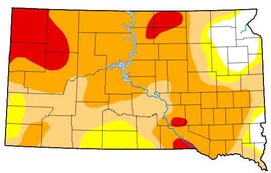
PIERRE — South Dakota’s U-S Drought Monitor map is continuing to show slight improvements after rain in late August and early September. Only four areas of extreme drought remain on the map. They include an area of southern Brule and extreme adjacent parts of Aurora and Charles Mix Counties. Extreme drought is also posted along the Missouri River in Charles Mix and Gregory County. Extreme drought is also showing up in McPherson, Campbell, Walworth and Edmunds Counties and in the northwest in Perkins, Meade, Harding and Butte Counties. Much of central South Dakota sits in severe drought north of Interstate 90. Moderate drought is posted in parts or all of Hughes, Stanley, Buffalo, Brule, Hand, Hyde, Lyman, Tripp, Jones, Jackson Mellette and western Haakon County. Southern Mellette and Tripp Counties are now considered abnormally dry. Areas of no drought remain south of Sioux Falls and in northeast South Dakota.

